Mapping in Addressing Election Issues
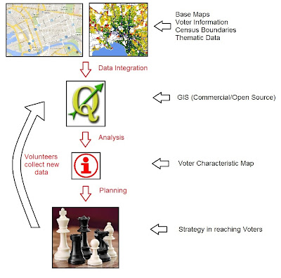
Since most countries around the world practice democracy and conduct elections, the success of elections is determined by the percentage of voter participation. The fate of the country and its future depends on voters and it takes sometimes a small number votes to change history. Voter participation fluctuate on election basis and could be strengthen if the election offices extend the registration of new voters. Depending on the country, local councils or states or federal government would be responsible in reaching out to new, unregistered voter. In order to create awareness, these institutions need to find ways to market the idea of registration in effective manner and GIS proves a decisive tool in this process.
Let's take an example, a council, south of San Francisco, (San Mateo) wanted an effective way of distributing resources in reaching out under-represented ethnic minorities in the area (targeting the Latino voters). The resources would be sending personnel familiar with Latino culture and voter materials that suit the needs of the community. The major question would be WHERE to send these resources. This is where GIS (or mapping in general) plays critical role.
 |
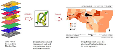
| Application of GIS in identifying potential voter registration program |
In the case of this council, they asked the service of GIS company to produce maps for this program The company intersected the datasets (refer to diagram above) in the GIS. The polygon data of the datasets were adjusted according to election boundaries and with that, the population per election district were quantified. Moreover, the maps produced showed where voter registration was low and how it correlates to the percentage of Latino community per election district.
The outcome would be reduced time, energy and financial costs in finding areas of low Latino registered voters. Secondly, the council can organize effectively to distribute culturally trained personnel and relevant language pamphlets to potential voters. Hopefully, it would have translated increased registrations.
Election Redistricting
Depending on each country, election redistricting (boundary delimitation) is done to balance the population of election districts. Any manipulation of election redistricting will result in gerrymandering and malapportionment (unequal voting distribution across election districts). Redistricting impacts the future of political process of the country and the funding allocated to the election districts. Prior to GIS, election officials would have used paper-maps and it is time cumbersome process and may result in unfavourable boundary outcomes. With the advent of GIS, census data (critical information for redistricting) can be overlayed on other election boundary data easily.
On top of that, some political institutions and selected American States have started using GIS to show transparency in election redistricting. These proposed election districts are shown online for the public to review. In the case of America, the users can propose back to election office of new election districts while able to access other documents related to election redistricting. All in all, this would allow better decisions to create fair distribution of electoral areas:
On top of that, some political institutions and selected American States have started using GIS to show transparency in election redistricting. These proposed election districts are shown online for the public to review. In the case of America, the users can propose back to election office of new election districts while able to access other documents related to election redistricting. All in all, this would allow better decisions to create fair distribution of electoral areas:
Malaysian Election Problem
In the case of Malaysia, the boundary delimitation rules stipulated in the constitution is vague. This becomes more obvious when election districts should not be redistricted in such a way that impact rural areas or reaching to voters become difficult. The ratio of the largest constituency to smallest constituency in Malaysia range from 1-4 (only 3 out 13 states had ratio between 1-2). In Projek Tindak Malaysia research, Durack, federal election (Australia) seat is 4.8 times of Malaysia and 50 times bigger than the biggest electoral district in Malaysia. Using Malaysian logic, Durack MP in theory have extreme difficulty in reaching the voters. While this is true, today's technologies will narrow the distance gap. Moreover, using Malaysian logic, Durack should be split in many districts. Basically, Malaysia has gerrymandering and malapportionment problem. Since election redistricting is geographical problem, GIS plays an important role in addressing gerrymandering in Malaysia. GIS can:
- Identifying areas where election districts have too many voters and too little voters.
- From this, we can zoom to election precinct level (in Malaysia called as daerah mengundi). At this level, election precints can be adjusted to the respective electoral areas with population thresholds. The GIS is able to overlay election boundaries and census data.
However, there are some challenges if voluntary election organization had to go through in any delimitation exercise
- Volunteers recruited have different mapping standards
- GIS data for election districts is hard to find or might be expensive for a voluntary project
- Malaysian Election Commission (SPR) maps have different geographical clarity and quality, thus complicating the delimitation mapping exercise
- Choosing the right software to draw the boundaries and subsequently display them for public viewer
Election Issue Awareness
Finally, maps are used by NGO groups or organizations to highlight and pinpoint issues pertaining to elections. Maps can piece complex data stories of elections into easy but powerful tools for election monitoring. For today's post, we'll take examples from Burma (Myanmar) and Malaysia
Above website documented the election violations that happened in Burma. The homepage shows a Simple Burma Map using Open Street Map as the base map. The red proportional circles highlight the number of election violations per region. From the homepage, the user can go to election violation subcategory. The circles on the map changes to reflect the spatial distribution of the violations. Having said that, clicking on the circle only provide the number of violations of the city or area. Specific incidents to election violations are only found via the text links on the website.
Finally, maps are used by NGO groups or organizations to highlight and pinpoint issues pertaining to elections. Maps can piece complex data stories of elections into easy but powerful tools for election monitoring. For today's post, we'll take examples from Burma (Myanmar) and Malaysia
 |
| Burmese Election Tracker Home Page |
For Malaysia, Sarawak Report with other media groups used MapBox (online mapping tool) to produce Election & Bribe Abuse Map of Malaysia.
 |
| Election Bribe & Abuse Map (Malaysia) |
This online map, compared to other to Burmese one, is better (I would say) as the user can share the link on social media, tweet and contribute reports to build the map more complete. The pop-ups have contain personal account or news report of election violation with combination of photos, the ability to comment and share the story. However, not all pinpoints are at the correct location plus some pinpoints contain news without much geographical component (i.e. cities). Moreover, the base map is bit too dark and should consider using another map instead. All in all, this online mapping tool is very useful and could be dynamic during election time
Sticking back to Malaysian election 2013 issue, BERSIH 2.0 (Coalition of Free and Fair Elections)- broad based NGO fighting for election improvements- posted on its Facebook page of a simple map on how Election Commission (SPR) arbitrarily divided voters in different constituencies.
 |
| Kampung Abdullah Voter Registration Pattern (courtesy of Bersih 2.0) |
"The map shows how our village, Kg Abdullah, established more than six decades ago in the late 1940s, being divided arbitrarily by the Election Commission in 2003. We plotted each of the voters according to their registered address and the map is the result: each red dot is a voter of P140 Segamat, and each blue dot is a voter of P141 Sekijang.
......We have known for a while that some of the voters were transferred out from the original P140 Segamat constituency to the newly created P141 Sekijang. But little did we know that it was so arbitrary, so 'unnatural' that the division bears absolutely no consistent patterns or principles of any sort. Many households ended up with "divided family" - some family members vote in P140 while the rest vote in P141. "
The map alone itself received 117 likes and was shared 169 times.
In short, the above examples illustrate how maps are effective communicator of election discrepancies and elections. Maps are just mere tools for the wider change. With more and more free online mapping tools (such as free base maps of Google or software like MapBox) available, activists and NGO are being more literate in using maps to communicate their ideas.
Sources:
- http://www.fargeo.com/presentations/gis_for_gotv_campaigns.pdf
- http://computing.ornl.gov/internships/rams/archive/rams05/websites05/j_hemby/images/GIS_8LAYERS.jpg (For GIS Layers image)
- http://geography.uoregon.edu/infographics/lcweb/images/countyto.gif (Oregon Map Voter Turnout)
- http://wpsa.research.pdx.edu/meet/2012/hanewicz.pdf
- http://www.tindakmalaysia.com/showthread.php/7041-Delimation-FAQ
- http://www.ndi.org/election-stories-unfold-on-a-map
- http://election.sarawakreport.org/#6/3.57921/108.39111
- Kg Abdullah Map was sourced Bersih 2.0 Facebook Page (21st September 2013)


