Though you may associate a lot of my works as GIS outputs, I prefer to be identified as a cartographer first, then GIS analyst second. Recently, I read an article on bad maps where maps are known to lie, maps built on dodgy sources and thematic colouring built on poor classification.
Today, we will be looking through some of my sample maps and explore the concept and design of the map.
Maps of LIDAR and 3D Visualizations
 |
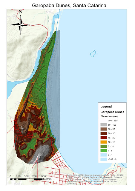
| Garopaba Sand Dunes derived from LIDAR Data |
Recently, I found out that my company had access to free 10 ESRI courses. I signed up one of them -Creating 3D Data Using ArcGIS. Though I have learnt this back in university, it was a good refresher course. It exposed to me many principles I need to consider when developing a 3D model. Subsequently, I signed up for another course of managing LIDAR data (Laser and Detection Ranging) but only to realize my ArcMap account in my company had restricted licence. My GIS hands became itchy and sourced LIDAR data and make a 3D Model.
I was happy to find that high quality LIDAR data are freely available on the website (Open Topography). For this map discussion, we will not be dwelling on how I converted the massive file into a beautiful TIN. The study site is the sand dunes of small section of Santa Catarina state in Brazil. LIDAR Data provided shown two areas : Garopaba and Itapiruba. Due to the massive amount of data, I decided to produce a map of one region - Garopaba.
The map I produced above was the first step for my 3D fly through of the video. This map is an example of my effort to produce maps purely using ArcMap. Yes, purely ArcMap product without the intervention of Illustrator. Some of the challenges producing the map above:
- What kind of data is needed to show for the area? The road network, water areas etc.
- The difficulty in finding a dataset that fits for this large scale map. This area is extremely small part of large Brazil
- How much data should I put for this area? Remember, the focus is on the sand dunes, not the cities around it.
- Classification of the elevation heights of Sand Dunes. I will not accept the categorization given by ArcMap. Unfortunately, some of the elevation heights included the Atlantic Ocean (shown in the map above). Choosing a colour scheme representative of the reality of the ground is tricky. I want the users to 'feel' the sand dunes
- How much information should I put in the Legend? Is the Legend sufficient for a lay person to comprehend the map?
- ArcMap has couple of options for you to add dynamic text: service credits, author name. By choosing one of the options (i.e. service credits for datasets), is there too much information?
 |
| 3D Visualization of Batu Reservoir (Selangor, Malaysia) |
The above map was purely a screen grab from ArcScene. Now, I ask you some questions for the above map.
1) Does this 3D visualization need a legend?
2) Is the Reservoir clearly visible for your eyes?
3) In this visualization, which stands out most for you? The road network, the lake or the mountains?
Environmental Map of Yasuni - Map built on complete thought process
 |
| Environmental Map of Yasuni |
This map I have circulated on social media garnered many likes and 1 pluses. One of my more popular maps I have to say. However, let's understand the context on why I produce this map.
Firstly, I had an original plan to produce a gift map of Ecuador. I was inspired by one of the Yasuni maps shown in National Geographic Magazine map. Tested myself whether I can produce a map of similar quality to National Geographic purely from ArcGIS. This map was built on with proper thought process.
Since this is an environmental issue, I have identified that location of oil fields, forest areas, indigenous settlements and road networks are critical for the user the factors of this issue. How did I figure out what kind data needed? A lot of reading of articles and doing deduction from the articles.
After listing out, the search of the data commenced. I pulled as much data as possible and documented the sources. However, not all layers are going to be used in the map. I placed all the possible layers in ArcMap.
Subsequently, I did the classification of the elevation layer and choosing right colours for other layers. After this stage, I reached an important turning point - placing the labels. Since the map is to be done completely in ArcMap, I utilized Maplex Label Engine to have my labels at the best possible positions. It was here that I decided which layers ought to be removed and ought to be kept. Too many data layers clutter the map, makes the labels not legible and distract the user.
With labels placed, I have experimented significantly the colour schemes to ensure the map is legible and easy to understand.
When this map was posted on social media, I received insightful comments (aside 'nice work'):
- Do we need to tell the users the red lines are roads in Legend?
- The user spotted that a river line in the scale bar. Maybe need to find where in ArcMap scale bar setting you can make the changes
- Should I make the roads thicker and river lines thinner? As roads are more important than rivers for this map context?
- A better location for the North Arrow?
- Should I put an inset map the location of this area in a wider region?
Thematic Map of Diaspora Communities
 |
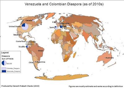
| Simple Distribution Map built on strong research |
Similar to my other products, this thematic map on diaspora communities was inspired by stories elsewhere. This map was built on much research and minimal effort on GIS part. To produce a map of diaspora like this, I faced numerous challenges:
- When searching the figures of the diaspora, I was challenged at many times what is the definition of diaspora? Does diaspora include permanent migrants and temporary migrants? How about refugees?
- The data currency was big issue. I want the latest data of diaspora community based on latest year. However, latest year figures vary from country to country. Hence I made a decision, the year variation should be kept less than 5 years.
- The source of data. It must come from credible source, not from Wikipedia. All Wikipedia sources have been checked thoroughly.
- I was bit disappointed that ArcMap did not a good job in creating the pie charts in the map above. There were some deficiencies which I found when I was formulating symbology for the diaspora figures
Conclusion
All in all, when producing maps, there are so many factors in producing and designing a map:
- What is your theme?
- Is it easy to get the data you need for the map?
- Does all the dataset you brought in are relevant for the map?
- What is the main focus of the map?
- Is your map legible, presentable and truthful?
When you consult me for a map, these are factors I taken into consideration to produce a thought provoking, beautiful and legible map!