 |
| Map of Venezuelan autopistas (highways) and major roads |
- Showing up-to-date topographic and political features of Venezuela
- Highlighting key features of Venezuela geographically (i.e. through maps) that have made impact past and present
I expect the project to be completed (when the map is pushed out) around December 2013. Official start date is 1/6/2013. No definite dates are in placed as it is hard for me to commit. Project title : Venezuelan Map Project
 |
| 8th Day into the Project (8/6/2013), after assembling the geospatial data |
Procedure
Stage 1: Collection of geospatial data (April- June 2013)
- Identifying the geographical datasets (e.g. terrain, road network, national park polygons)
- Creating a proper metadata for the datasets (metadata is data of 'data')- including the currency, sources, restrictions and others
- Determination of suitable Map Projection : Mercator Projection was Chosen
- Placing the datasets into one geodatabase (an ESRI geodatabase)
Stage 2: Map clean up (June 2013 - December 2013)
- Adding all necessary geographical datasets and arranging in appropriate order (i.e, roads must be over rivers)
- Classifying the datasets into proper hierarchies (e.g. road classification from highways to tracks)
- Removals of unnecessary datasets for the project (e.g. delete residential streets in the map)
- Choosing the right symbology for the datasets (e.g. choosing the right colours for terrain)
- Place text labels and modifications may be needed for positioning.
- Adding map grid
Stage 3: Map print-out (December 2013)
- Export ESRI (GIS software used for the map production) map to Adobe Illustrator
- Final complex touch-ups on the maps
- Adding images and notes on key geographical features of Venezuela (i.e. Angel Falls pop-up box or significance of Sabaneta, Barinas)
- Send for printing
 |
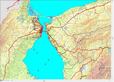
| Road classification around Lake Maracaibo |
Challenges
- Difficulty in getting good, consistent quality of geospatial data for Venezuela
- Unfamiliarity of Venezuela road hierarchies, significance of other geographic features
- Time constraints as I have multiple projects to do
- Getting bogged down in trivial mapping works.
- Uncertainty of project termination
- Cost involved in printing
- Suitability for the targeted audience (is it just for me?)
Hence, this what I have been doing in past few months. If I am called upon to do similar projects related to Malaysia, these are the procedures I follow and the challenges I will face
Thanks for your comment. How does this practically help you in future mapping works?
ReplyDelete