Pages

Total Pageviews

Thursday, 1 August 2013

Creating A1 Size Map of Venezuela

Venezuela
Map of Venezuelan autopistas (highways) and major roads
Today, the post is a sidetrack of my usual blog posts. Since late April I have been embarking on this massive map project on creating A1 Size map of Venezuela. The purpose of the map would be:
  • Showing up-to-date topographic and political features of Venezuela
  • Highlighting key features of Venezuela geographically (i.e. through maps) that have made impact past and present
I expect the project to be completed (when the map is pushed out) around December 2013. Official start date is 1/6/2013. No definite dates are in placed as it is hard for me to commit. Project title : Venezuelan Map Project
Venezuela Map at the 8th Day into Project
8th Day into the Project (8/6/2013), after assembling the geospatial data

Procedure

Stage 1: Collection of geospatial data (April- June 2013)
  • Identifying the geographical datasets (e.g. terrain, road network, national park polygons)
  • Creating a proper metadata for the datasets (metadata is data of 'data')- including the currency, sources, restrictions and others
  • Determination of suitable Map Projection : Mercator Projection was Chosen
  • Placing the datasets into one geodatabase (an ESRI geodatabase)
Stage 2: Map clean up (June 2013 - December 2013)
  • Adding all necessary geographical datasets and arranging in appropriate order (i.e, roads must be over rivers)
  • Classifying the datasets into proper hierarchies (e.g. road classification from highways to tracks)
  • Removals of unnecessary datasets for the project (e.g. delete residential streets in the map)
  • Choosing the right symbology for the datasets (e.g. choosing the right colours for terrain)
  • Place text labels and modifications may be needed for positioning.
  • Adding map grid
Stage 3: Map print-out (December 2013)
  • Export ESRI (GIS software used for the map production) map to Adobe Illustrator
  • Final complex touch-ups on the maps
  • Adding images and notes on key geographical features of Venezuela (i.e. Angel Falls pop-up box or significance of Sabaneta, Barinas)
  • Send for printing
Venezuelan Roads in Zulia State
Road classification around Lake Maracaibo

Challenges

  • Difficulty in getting good, consistent quality of geospatial data for Venezuela
  • Unfamiliarity of Venezuela road hierarchies, significance of other geographic features
  • Time constraints as I have multiple projects to do
  • Getting bogged down in trivial mapping works.
  • Uncertainty of project termination
  • Cost involved in printing
  • Suitability for the targeted audience (is it just for me?)
Hence, this what I have been doing in past few months. If I am called upon to do similar projects related to Malaysia, these are the  procedures I follow and the challenges I will face 


Friday, 12 July 2013

From 2D to 3D: Terrain Analysis for Housing Project


One year ago, my good friend from civil engineering background approached me to interpret the contour file in CAD (Computer Aided Drafting) software. The project was about building housing scheme and terrain play important role which house types should be built. When I first looked (above) the CAD file, my first impression was I was this area is damn steep for housing area. Look how closely the contour lines are found in this area (creating steep impression). My friend told me it is gentle rising slope area but I was compelled to convert DWG into 3D model of this area.

                          
                                 The Drawing file (DWG) of CAD converted into shapefile in ArcGIS


After receiving the drawing file (DWG), the first step was to convert it to a shapefile so that I can view in ArcGIS. For this particular project, I wasn't concerned about the metadata, the accuracy of the DWG file or the coordinate system. In ArcMap (at that time v. 9.3), I think I have used the 'Add Data' to import the file. Instantly, the file is added as multiple layers (as polylines, points and others). Since it lacks projection, ArcMap issues a warning that the DWG file lacks coordinate system. Since around 5 layers have been derived from the DWG, I decided to export all these layers to shapefiles. I right clicked on layer (i.e. NarNarGoonSurface_2012_dwg_Polyline), go to 'Export Data' and save the shapefile in my directory.
With some play with symbology, the (above) contour map is created.

(For more instructions, follow link:  http://gpshort.uga.edu/instructions/gis/Convert%20an%20AutoCAD%20file%20to%20a%20Shapefile%20and%20Georeferencing.pdf)

Triangulated Irregular Network (TIN) in ArcMap
First of all, in GIS (Geographic Information Science), we have different terms for representing elevation layer (i.e. DSM, DTM, DEM, TIN). The shapefiles just know we have created are in vector data format (data that stores point, lines and polygons). Triangulated Irregular Network (TIN) is vector based terrain representation. Basically, it is network of triangles connected by vertices and from there, terrain layer is generated. In the ArcToolbox on your left hand side, go to 'Data Management', the proceed to 'TIN' and from there, choose 'Create TIN'. A pop-up box appears, choose where to save the TIN file and nominate the shapefile. The (above) TIN is generated. In ArcMap, you can start seeing that the TIN looks like in 3D format.
3D Terrain of the Housing Project Area
The final stage is to bring the TIN to ArcScene (the part of ArcGIS which is focused on 3D Modelling). In Arc Scene, go to 'Add Data' and import the TIN file. Instantly, it appears as real world surface in action. In ArcScene, you can add contours, add other annotations and even do a Fly Around.

That's wrap up the story of transforming from 2D dataset to 3D Terrain Surface.

(For more information, refer to this link,http://crl.ap.buffalo.edu/digitalworkshop/zcorp/pdfs/Creating%203D%20Models%20Using%20ArcGIS.pdf)


Wednesday, 10 July 2013

University Enrolment in Malaysia Map

Today's topic would be on Malaysian Universities, their enrolment and population of Overseas Malaysian Students. These maps will be treated under construction and more data would be placed in future (I shall inform you accordingly). I would like to acknowledge Kementerian Pengajian Tinggi  (Minsitry of Higher Education-MOHE) for statistics.

Malaysian Public University


View Larger Map

The above map shows the location of main campus of the Malaysian Public Univerisities. The size of circle based on the enrolment student total in 2011.
Instructions:

  1. Click the 'View Larger Map' for more information. 
  2. In the about Section, go to 'More Content'
  3. New page appears, go to 'Open'
  4. Press 'Open to ArcGIS Explorer Online'
  5. In the map, click on the circle (a university), watch the dashboard on right and hover another university for comparison

The location of campus were obtained through Wikipedia and Google Maps

International Students/ Overseas Malaysian Students Composition


View Larger Map
The above map shows the map of Malaysian Students studying abroad (in 2011).
Instructions:


  1. Click the 'View Larger Map' for more information. 
  2. In the about Section, go to 'More Content'
  3. New page appears, go to 'Open'
  4. Press 'Open to ArcGIS Explorer Online'
  5. In the map, click on the circle (a university), watch the dashboard on right and hover another university for comparison
The location of country centre points were obtained indirectly from Natural Earth website latest data. I do not endorse the boundaries and their representations on the maps above.
Danesh, the Producer, strongly welcome criticisms, praise and suggestions to improve from the readers. Please use the map as a general reference.

Tuesday, 28 May 2013

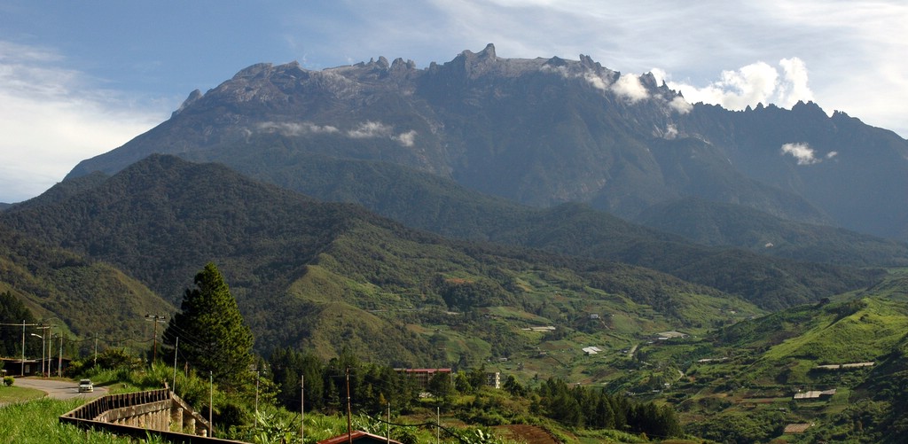
Is Mount Kinabalu the Highest Mountain in South East Asia?

Mt Kinabalu (by Oscark for Wikipedia)
In 2004, I got the opportunity to travel Sabah (in Borneo) for the first time and part of the trip was to hike Mt Kinabalu. Prior to my incomplete ascent of the mountain, the guide stated the fact Mt Kinabalu is the highest mountain in South East Asia. My dad said to the guide that I disagreed the fact. So the guide changed bit of his mind, said for in terms of accessibility in SE Asia, it would be highest

For Malaysians, in our geography textbook states that Mt Kinabalu is the highest mountain in South East Asia and its height is 4101 metres. IT was taken as a fact but soon, some of us argue that statement is false and others insist the fact Mt Kinabalu is the highest in South East Asia. Let's dissect this statement into two categories:
Mt Kinabalu
The highest Mountain in South East Asia
It's height is 4101 metres

In 1997, using satellite technology, Mt Kinabalu lost 6 metres on its height (revised height is 4095.2 metres). This is nearly the same height of Mount Cameroon (subject to change), the highest mountain in Cameroon. Unfortunately, the old height figure got crossed over to the revised Geography Syllabus of 2003.

FELLOW READERS, THE HEIGHT OF MOUNT KINABALU IS 4095.2 M, NOT 4101M

That leaves the first statement in dispute. I decide to poll my friends view on this matter. 23 people participated. The question posed: 'Is Mt Kinabalu the Highest Mountain in South East Asia?' The responses as below:

Survey Results:
Yes: 35%
No: 61%
I don't know: 4%

I am going to argue for reasons of Yes and No for the question

Yes

Those who argue on this premise may believing in what Malaysian Geography Syllabus stated long time ago. Some may said yes based on their research on websites.
Argument 1
The whole issue of this dispute stems from the fact what defines South East Asia. To nominate Mt Kinabalu as the highest peak in SE Asia, Burma and New Guinea should be defined outside of SE Asia. Burma used to be part of British India, so it should be included to South Asia category. New Guinea is claimed to be the largest island in Oceania. In Burma, there is Hkakabo Razi (5881 m) and Indonesian Side of New Guinea have four to five mountains higher than Mt Kinabalu. By kicking out Burma and New Guinea, your claim is correct.

Argument 2
Some of you argue, Burma is part of SE Asia and New Guinea (including Papua, formerly Irian Jaya) is part of Oceania. On that premise, you argue that Hkakabo Razi is part of Himalayas and it is very close or on the borders with China/India. Since it is part of Himalayas and bordering on other countries, Hkakabo Razi cannot be claimed to be highest. In short, its claim is disputed. You may point that language family group of people residing around the mountains is more related to China, than to South-East Asia.

No

Over the years, some of us fell love in geography or did some further research. What they found disproved the fact Mt Kinabalu is the highest mountain in SE Asia
Argument 1
South East Asia is defined from Myanmar (Burma) to Indonesia (Papua Region). ASEAN includes Burma and because of this, Hkakabo Razi is the highest mountain South East Asia. United Nations for statistical reasons put Myanmar in South East Asia, not in South Asia. In Papua alone, there are four to five mountains exceeding 4100 metres. Puncak Jaya (4884 m - not the old figure of 5030 m) is the highest peak in Papua, the highest  island mountain in the world and the highest mountain between Himalayas and Andes. Definitely, these two peaks are much higher than Mt Kinabalu

On this premise, Mt Kinabalu can get the consolation prize for being the highest mountain between Himalayas and New Guinea or the Malay Archipelago (excluding New Guinea).

Argument 2
This argument is subset of the first argument. Assuming Google Maps border is correct, I found that Hkakabo Razi lies wholly within Burma (it is close to the border with China). Even if it shares the border with China, it wouldn't matter. For example, Mt Everest is the highest mountain for both China and Nepal. On that premise, Hkakabo Razi rightfully claim the title of the highest mountain South East Asia

Concluding Remarks

In my opinion, I would say no to the fact Mt Kinabalu is the highest mountain in South East Asia (even the official Mt Kinabalu park website would say that). I am basing my stance with above arguments.

However, I am not implying the fact those who said Yes were duped or lied or totally wrong. It goes back to the question, 'Where are the borders of  South East Asia?'. Does a mountain shared by two countries could claim be part of SE Asia?

I leave it to you guys to decide on this matter.

P.S. I would like to credit UN, Wikipedia, Other blogs, other websites for building these arguments.


Thursday, 16 May 2013

North-South Expressway Highway Map


View Larger Map

After one month plus working on gathering and organizing the data, finally, it is done. PLUS FM/ HIS (+) contains around 810 geographical features and facilities along the North South Highway (Malaysia).
Abbreviation explained:
PLUS FM- PLUS is the common name for the highway and FM stands for Facility (or Feature Map)
HIS (+)- Highway Information System (PLUS)

Both maps (inc. link below) are two takes on the geographical data that I have collected over the years on field and online research. Facilities/ Features shown are:

  1. SOS (Emergency telephones)- not publicly available online
  2. Rest Areas
  3. Laybys
  4. Motorcycle Sheds- not publicly available online
  5. Points of Interest
  6. Interchanges
  7. Tolls
  8. Named River Crossings- mostly not publicly available online
PLEASE ZOOM IN TO SEE MORE DETAILS (i.e. Facilities)

A link to another take on this map:
http://www.arcgis.com/explorer/?open=3548c8b8efae4077a8745f61581ec2e3&extent=11244978.3274989,513126.407464766,11261574.7459163,520428.345582528

Important Notes on the Map


Producer: Danesh Prakash Chacko (April-May 2013)

Source: Personal Field Collection/ GPS Collection, Panoramio, Wikipedia, PLUS (official website) Google Maps, Google Earth, Bing Maps, Foursquare.

Accuracy: Refer to accuracy statement found in each feature found in the map. Where it is left blank, it should be assumed as point positioned at 1 km viewing altitude in Google Earth or Navman GPS accuracy level (for SOS).Use the positional accuracy as a guide only, not for in-depth accurate mapping studies.

Currency: The map data as current of November 2012 (for rest areas and laybys, refer to date currency of PLUS website). However, the producer asks the users to use discretion when using the map and validate themselves on the highway.

Disclaimer: The producer has done his best to collect the information with relevant positional and attribute accuracy. His personal notes have been cross-referenced with other sources such as Panoramio and vice-versa. However, the producer disclaims himself for any mishaps or intentional/unintentional misuse of the data as a result using the map. Producer have omitted some of the data to preserve the general integrity of the data accuracy. In future, more data will be added to complete the map

Acknowledgement: I, the producer, would like to acknowledge fully all the online references (stated above) which were used for the completion of the project. I hereby ask all users to quote all the references mentioned above (or in the map) when the data is being utilized elsewhere. This is in spirit of recognition of other unknown contributors and respecting copyrights.

THE PRODUCER WILL INFORM THROUGH HIS BLOG FOR ANY UPDATES/ADDITIONS/OMISSIONS FOR THE MAP. ANY UNAUTHORIZED EDITS WITHOUT CONSENT OF THE PRODUCER WILL RESULT THE PRODUCER DISQUALIFY HIMSELF FROM ANY WRONG-DOINGS AND/OR ITS SUBSEQUENT CONSEQUENCES

MINOR NOTES (FAQ)

1) What is a viewing altitude mentioned in accuracy section?
Viewing altitude of Google Earth

You will encounter a statement saying called 'Google Earth 1.5 km viewing altitude'. The position of the facilities such as Fuel Stations were placemarked by me at 1.5 km (e.g.) height at Google Earth. The above image shows a red circle referring to viewing altitude. If I ever bring this across to an online Google Map/Earth, you can zoom in to this facility with great accuracy until hits 1.5 km viewing altitude

2) I find some of the information sections left empty for facilities. Why is this so?
For attributes (the description of the facilities), it means either this facility do not have particular attribute (laybys that do not sell fruits, so when you click the pin, fruit section is empty) or the accuracy statement was mysteriously have not been added. Over time, I may add the accuracy statement that were missing for selected facility categories (i.e. Emergency Telephones)

3) What do you mean 'digitized at 1:20000 in ArcGIS'?
Let's take an example- River Crossings. Most of the river crossings were place marked in Google Earth. They were subsequently imported to ArcGIS (mapping software). Over time, I realized that I missed two or three river crossings. To save time, I manually added them to the nearest .000 degrees (for latitude or longitude) in ArcGIS map at the scale of 1:20 000.

4) I noticed in reality, emergency telephones are not exactly correspond to the highway chainages listed in the map. Is there an error in your map?
Most of the emergency telephones I listed in the map have some highway chainage. For example, there is an SOS on Sungai Buloh exit ramp and its highway chainage is KM 453.9. In reality, the highway chainage listed is the one closest to this SOS. It doesn't mean this SOS is at KM 453.9. At rare instances, both the chainage and SOS location would correspond.

Friday, 3 May 2013

Fusing Your Passion with Maps

Today, I would like to present or promote another website. We hardly see people relating mapping with other passions they have. More so, from a sporting perspective. I have a contact, who was the Managing Cartographer of the World's Largest Atlas, The Earth. Now he works for ESRI in America which is one of global leaders and pioneers of the GIS industry. I know he is passionate in making maps and reading his website, equally passionate on Tennis. This blog I presenting shows the linkage of his passion in mapping science and Tennis.
http://gamesetmap.com/

-Unknown to much of the world, GPS and GIS is and could be used as powerful tools for Sporting events-

Thursday, 2 May 2013

Free GIS Dataset site

While I am still working on Online Map of North-South Highway Facilities, I decided to present you a link that is an interest for all map-makers. We all need digital data, but they are not free. Below here is the link that can give you a heads-up for any of your project:
http://freegisdata.rtwilson.com/#home

If possible, do help out the person in charge of website to provide other potential free GIS data depots online or other means of helping too. I use the site on and off to get datasets for paper-map production.

You might note that Malaysia is not listed. I would like to take the opportunity that if you want to take my data from maps, You are allowed for non-commercial purposes/educational/personal/non-profit/presentation purposes. This is to be fair. This means you can attribute the source of data to my blog address.